![](/images/other/stat-length.png)
![Excursión Senderismo Les Belleville - lac du lou - Photo](https://media.geolcdn.com/t/1900/400/ext.pjpeg?maxdim=2&url=https%3A%2F%2Fstatic1.geolcdn.com%2Fsiteimages%2Fupload%2Ffiles%2F1553511878bg_sport_marche.png)
lac du lou
gilsep
Usuario
![Longitud](/images/other/stat-length.png)
Longitud
6,9 km
![Altitud máxima](https://static1.geolcdn.com/siteimages/upload/files/1508320355ic_sort_altitude_max_24dp.png)
Altitud máxima
2051 m
![Desnivel positivo](https://static1.geolcdn.com/siteimages/upload/files/1508320355ic_sort_den_pos_24dp.png)
Desnivel positivo
307 m
![Km-Effort](/images/other/stat-length.png)
Km-Effort
11 km
![Altitud mínima](https://static1.geolcdn.com/siteimages/upload/files/1508320355ic_sort_altitude_min_24dp.png)
Altitud mínima
1759 m
![Desnivel negativo](https://static1.geolcdn.com/siteimages/upload/files/1508320355ic_sort_den_neg_24dp.png)
Desnivel negativo
303 m
![Boucle](https://static1.geolcdn.com/siteimages/upload/files/16400158638029165_repeat_loop_refresh_sync_direction_icon.png)
Boucle
Sí
Fecha de creación :
2019-01-15 13:12:20.299
Última modificación :
2019-01-15 13:12:20.299
![Senderismo](https://static1.geolcdn.com/sitytour/trail-icons/101.png)
2h17
Dificultad : Fácil
![Escanee este código QR para abrir la excursión en la aplicación SityTrail](https://capi.geolives.com/qq0zvz2zws4bq2lad0pu/sitytour/trails/1006210/qr.png?size=200)
Aplicación GPS de excursión GRATIS
A propósito
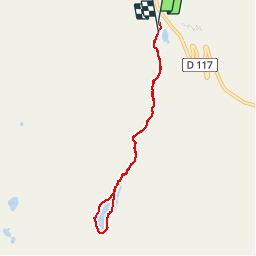
Ruta Senderismo de 6,9 km a descubrir en Auvergne-Rhône-Alpes, Saboya, Les Belleville. Esta ruta ha sido propuesta por gilsep.
Descripción
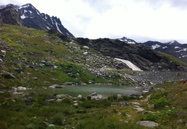
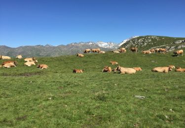
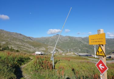
Jolie promenade dans l'alpage et tour du lac du lou.
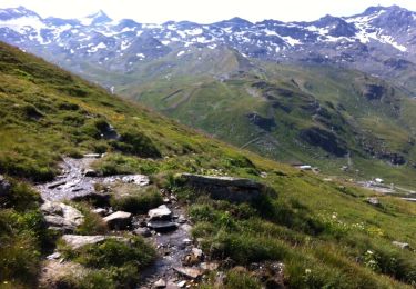
Départ du parking des bruyères ou du plan de l'eau.
Chemin bien balisé, pas de difficulté particulière. Attention autour du lac, certaines pierres sont glissantes
Localización
País:
France
Región :
Auvergne-Rhône-Alpes
Departamento/provincia :
Saboya
Municipio :
Les Belleville
Localidad:
Saint-Martin-de-Belleville
Salida:(Dec)
Salida:(UTM)
307006 ; 5020650 (32T) N.
Comentarios
Excursiones cerca
![Excursión Senderismo Les Belleville - FR - VAL THORENS - Circuit des lacs de Val-Thorens - Photo](https://media.geolcdn.com/t/375/260/ext.jpg?maxdim=2&url=https%3A%2F%2Fservices.sitytrail.com%2FGeolivesWS%2FDownloadMedia.ashx%3FTrailID%3D333495%26Media%3D20140811122637.jpg)
![Senderismo Senderismo](https://static1.geolcdn.com/sitytour/trail-icons/101.png)
FR - VAL THORENS - Circuit des lacs de Val-Thorens
Senderismo
Muy fácil
(1)
Les Belleville,
Auvergne-Rhône-Alpes,
Saboya,
France
![](/images/other/stat-length.png)
6,2 km | 8,6 km-effort
4h 15min
![](https://static1.geolcdn.com/siteimages/upload/files/16400158638029165_repeat_loop_refresh_sync_direction_icon.png)
Sí
![Excursión Senderismo Les Belleville - FR - VAL THORENS - Lac du Montaulever - Photo](https://media.geolcdn.com/t/375/260/ext.jpg?maxdim=2&url=https%3A%2F%2Fservices.sitytrail.com%2FGeolivesWS%2FDownloadMedia.ashx%3FTrailID%3D332855%26Media%3D20140810110245.jpg)
![Senderismo Senderismo](https://static1.geolcdn.com/sitytour/trail-icons/101.png)
FR - VAL THORENS - Lac du Montaulever
Senderismo
Muy fácil
(2)
Les Belleville,
Auvergne-Rhône-Alpes,
Saboya,
France
![](/images/other/stat-length.png)
4,5 km | 8,3 km-effort
2h 9min
![](https://static1.geolcdn.com/siteimages/upload/files/16400158638029165_repeat_loop_refresh_sync_direction_icon.png)
Sí
![Excursión Senderismo Les Belleville - le lou-la masse-les lacs - Photo](https://media.geolcdn.com/t/375/260/ext.jpg?maxdim=2&url=https%3A%2F%2Fservices.sitytrail.com%2FGeolivesWS%2FDownloadMedia.ashx%3FTrailID%3D601214%26Media%3D20160720162358.jpg)
![Senderismo Senderismo](https://static1.geolcdn.com/sitytour/trail-icons/101.png)
le lou-la masse-les lacs
Senderismo
Muy difícil
(1)
Les Belleville,
Auvergne-Rhône-Alpes,
Saboya,
France
![](/images/other/stat-length.png)
23 km | 43 km-effort
7h 2min
![](https://static1.geolcdn.com/siteimages/upload/files/16400158638029165_repeat_loop_refresh_sync_direction_icon.png)
No
![Excursión Senderismo Les Belleville - Le sentier des Choumes ( N °9) - Photo](https://media.geolcdn.com/t/375/260/5cb3a0b1-6ffc-4a97-954a-79c4931bc02f.jpg&format=jpg&maxdim=2)
![Senderismo Senderismo](https://static1.geolcdn.com/sitytour/trail-icons/101.png)
Le sentier des Choumes ( N °9)
Senderismo
Fácil
Les Belleville,
Auvergne-Rhône-Alpes,
Saboya,
France
![](/images/other/stat-length.png)
6,7 km | 8,8 km-effort
1h 36min
![](https://static1.geolcdn.com/siteimages/upload/files/16400158638029165_repeat_loop_refresh_sync_direction_icon.png)
No
![Excursión Senderismo Les Belleville - N°1 - La découverte des village au fil du Doron - Photo](https://media.geolcdn.com/t/375/260/15306859-1875-4a25-b739-668d92dd6d6e.jpg&format=jpg&maxdim=2)
![Senderismo Senderismo](https://static1.geolcdn.com/sitytour/trail-icons/101.png)
N°1 - La découverte des village au fil du Doron
Senderismo
Fácil
Les Belleville,
Auvergne-Rhône-Alpes,
Saboya,
France
![](/images/other/stat-length.png)
9,4 km | 12,4 km-effort
1h 54min
![](https://static1.geolcdn.com/siteimages/upload/files/16400158638029165_repeat_loop_refresh_sync_direction_icon.png)
No
![Excursión Senderismo Les Belleville - Le sentier Giraud - N° 8 - Photo](https://media.geolcdn.com/t/375/260/f9a4a370-f6ae-440a-97ef-2e1286f7b148.jpg&format=jpg&maxdim=2)
![Senderismo Senderismo](https://static1.geolcdn.com/sitytour/trail-icons/101.png)
Le sentier Giraud - N° 8
Senderismo
Fácil
Les Belleville,
Auvergne-Rhône-Alpes,
Saboya,
France
![](/images/other/stat-length.png)
5 km | 6,5 km-effort
1h 9min
![](https://static1.geolcdn.com/siteimages/upload/files/16400158638029165_repeat_loop_refresh_sync_direction_icon.png)
No
![Excursión Senderismo Les Belleville - La Croisette - Le Plan d'eau des Bruyères - Photo](https://media.geolcdn.com/t/375/260/debed00d-5703-4a8c-a041-854ec81465b6.jpg&format=jpg&maxdim=2)
![Senderismo Senderismo](https://static1.geolcdn.com/sitytour/trail-icons/101.png)
La Croisette - Le Plan d'eau des Bruyères
Senderismo
Fácil
Les Belleville,
Auvergne-Rhône-Alpes,
Saboya,
France
![](/images/other/stat-length.png)
7,7 km | 10,5 km-effort
1h 53min
![](https://static1.geolcdn.com/siteimages/upload/files/16400158638029165_repeat_loop_refresh_sync_direction_icon.png)
Sí
![Excursión Senderismo Les Belleville - Lac du Lou - Photo](https://media.geolcdn.com/t/375/260/2753a11b-3e3e-4ec9-8c50-abd7984db138.jpg&format=jpg&maxdim=2)
![Senderismo Senderismo](https://static1.geolcdn.com/sitytour/trail-icons/101.png)
Lac du Lou
Senderismo
Medio
Les Belleville,
Auvergne-Rhône-Alpes,
Saboya,
France
![](/images/other/stat-length.png)
11,3 km | 15,5 km-effort
4h 38min
![](https://static1.geolcdn.com/siteimages/upload/files/16400158638029165_repeat_loop_refresh_sync_direction_icon.png)
Sí
![Excursión Senderismo Les Belleville - descente point de la masse - Photo](https://media.geolcdn.com/t/375/260/ext.jpg?maxdim=2&url=https%3A%2F%2Fstatic1.geolcdn.com%2Fsiteimages%2Fupload%2Ffiles%2F1553511878bg_sport_marche.png)
![Senderismo Senderismo](https://static1.geolcdn.com/sitytour/trail-icons/101.png)
descente point de la masse
Senderismo
Medio
(1)
Les Belleville,
Auvergne-Rhône-Alpes,
Saboya,
France
![](/images/other/stat-length.png)
9,3 km | 13,3 km-effort
3h 30min
![](https://static1.geolcdn.com/siteimages/upload/files/16400158638029165_repeat_loop_refresh_sync_direction_icon.png)
No